The Yoker-Renfrew Ferry, and swans.
The hat has to come off for the Yoker-Renfrew Ferry which in one shape or form has been plying its trade for half a millenium. Without this balletic beauty many of my excursions to the southern hills would have lost much of their initial oomph. Pirouetting across the Clyde (it's barely a one minute crossing across 50-200m depending on the water level) you can see the Kilpatricks in all their glory mid-stream. There are actually two ferries that alternate: The Renfrew Rose and The Yoker Swan, so called after the two neighbourhoods on either side of the river, and after the family of swans that reside here. Sadly, there was talk of Strathclyde Passenger Transport dismantling the service but it looks like (after totting up their sums) they're going to keep it.
The Falkirk Wheel (or at least the top of it) and the Ochil Hills behind. The Falkirk Wheel solves the problem of joining two canals and reconciling a height difference of some 24m between the Union Canal and the Forth and Clyde Canal. It is a masterpiece of engineering and the views ain't too bad either. The Roman fort of Rough Castle, part of the Antonine Wall, is located nearby.
The Art Deco facade of the India of Inchinnan building designed by Thomas Wallis in 1930. It lies on the Old Greenock Road just over the Black Cart Water and the wonderful Inchinnan Bridge.
The George Buchanan obelisk in the lovely village of Killearn. Buchanan (later to become the Latin Professor and Prince of Poets of a youthful Michel de Montaigne) went to school here in the village and no doubt took a stravaig or two into the surrounding Campsies. He was packed off to Paris at the age of 14 by his uncle. His grave can be seen in Greyfriars Kirkyard in Edinburgh.

Over in Hamilton Low Parks stands the Hamilton Mausoleum built in 1858 for the 10th Duke of Hamilton. With the exception of the Pyramids and the Taj Mahal (and probably a few others) it is said to be the largest mausoleum in the world. The Hamilton Mausoleum is also reputed to possess the 'longest echo' (15 seconds) of any building in Europe. More interestingly perhaps, the edifice is now 15 feet lower than when it was built due to subsidence caused by coal mining. Much of the Hamilton family's wealth (of whom it has been said that their history is the history of Scotland) came from mining rights in the 19th century. The Hamilton Palace has already fallen foul of subsidence. It's only a matter of time before the mausoleum keels over too, if nothing is done to stabilise it. Andy Smith (bottom right) gives this magnificent structure a sense of dimension. It really is humungous!

Robert Tannahill's cottage in Paisley.

Bowling basin on the road to Dumbarton. This is where the Forth and Clyde Canal begins/finishes on its way to/from the Firth of Forth on the other side of Scotland. Behind you can clearly make out the rising stony Kilpatrick Braes. From Bowling heading east there is an old railway path which continues towards Dumbarton and its wonderful castle. From there heading north along the River Leven it's another 10km or so past Renton and Alexandria up to Balloch and the gateway to the Scottish Highlands, Loch Lomond.

The Livingstone iron suspension footbridge across the Clyde connects Bothwell with Blantyre, two peripheral towns renowned for their history. On the Blantyre side of the bridge is the former birthplace of the explorer David Livingstone which is now a museum, and on the Bothwell side, aside a few plush housing developments sits the red-bricked castle of Bothwell, begun in the 13th century by the ancestors of the Clan Murray. The area is positively steeped in history with Strathclyde country park just up the road boasting the excavated remains of Bothwellhaugh Roman Fort and bath-house as well as an arched Roman bridge.

This odd structure just past Bearsden lies on the Drymen Road opposite the ski-centre. With its modular interlocking concrete forms it reminds me of Moshe Safdie's 'Habitat '67' in Montreal. In fact, thanks to this structure's hilltop views across the city and the country, and its slightly less frenetic format, I would say this building (in spite of its austere grey facade) is less imposing and more gentle than Safdie's. Set against a february blue sky and with the rolling grassy knoll in front of it, its grey frontage actually seems appropriate. Whatever the case as to its aesthetic appeal, there's no denying this stony audience's capacity to provoke.

MARYHILL owes its existence to the building of the Forth and Clyde Canal in the late 17th century when it developed as a centre of heavy industry, including shipbuilding. This series of 5 locks down the hill was all part of the overall canal design by John Smeaton. Construction of the canal started in 1768 and after delays due to funding problems was completed in 1790.
Until the Forth and Clyde canal came along, there was very little thereabouts apart from the rural estates of several leading Glasgow families - and some light industry such as paper making along the River Kelvin. But the Kelvin was soon superseded by the canal, the triumph of the latter symbolised by the mighty Kelvin Aqueduct built from 1787-90 which carried the canal haughtily over the river on four heavy masonry arches. The Kelvin's water powered mills were also superseded by the clatter of steam engines as industries migrated to the banks of the new waterway.

'Cormorants on the Kelvin' - This, the central pillar of the former rail bridge here, is by far the favourite of the three remaining pillars for those cormorants. Today, it's a real gathering with eight of them drying off in the sporadic November sunshine.

The Kelvin Acqueduct with Gilsochill Estate in the background.

The Kelvin Aqueduct was a wonder of the world, the mightiest built possibly since Roman Times, and tourists flocked to see it, including crowned heads of Europe. It was the technical key to the Forth and Clyde Canal, itself the artery of the first phase of Scotland's Industrial Revolution. The engineer in charge of its construction was Robert Whitworth, and the cost of the structure, at £8500, almost bankrupted the company building the canal.
Scheduled as an Ancient Monument, were this structure in some rural retreat it would be visited by thousands; I doubt if more than a handful of the curious come to see it today.

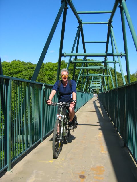
A cautious grey heron and a cyclist on the towpath down towards the Erskine Bridge and Old Kilpatrick.

The Luma Lamp Building just off the M8 behind the Southern General Hospital. The former Luma Lamp Factory on Shieldhall Road is included in the Scottish Minister's List of Buildings of Special Architectural or Historic Interest as category 'B' listed. Its distinctive and principal feature is a tall conning tower situated at the south west corner rising to a height of 84 ft. The building was completed in 1938 to coincide with the Empire Exhibition sited in nearby Bellahouston Park (which contained the very wonderful 'Taits Tower'), and was the result of a joint effort of the Wholesale Societies of Scotland and Sweden, which in turn led to the formation of the British Luma Cooperative Lamp Company, as the Glasgow HQ of the first international cooperative factory for the manufacture of electric lamps..

There is a poetry to bridges that escapes most.
The Clyde Arc (aka. the squinty bridge) at dusk.

From Bishopton looking north at the Blantyre Obelisk and the Kilpatrick Braes in the background.


No comments:
Post a Comment